Dow's Lake
The neighbourhood east of the lake on the Rideau Canal, south of Carling Avenue and west of Bronson Avenue, next to the Glebe.
* Ottawa Neighbourhood Study figures for its “Glebe - Dows Lake” area, which is larger than Dow's Lake alone.
Dow's Lake is a small man-made lake on the Rideau Canal in the middle of Ottawa, and the neighbourhood sits on its east side. The Ottawa Neighbourhood Study's 'Glebe - Dows Lake' area had 13,565 residents in the 2021 census.
Updated · Facts on this page link to their sources
About Dow's Lake
Dow's Lake is a small man-made lake on the Rideau Canal in the middle of Ottawa, and the neighbourhood sits on its east side. Wikipedia places it north of the Rideau Canal, east of the lake, south of Carling Avenue and west of Bronson Avenue, and counts it as part of the Glebe area. Around the lake are Commissioners Park, which holds the Canadian Tulip Festival beds each May, a pavilion with boat rentals, and the Dominion Arboretum to the west. Dows Lake Station on O-Train Line 2 is nearby. The census figures use the ONS 'Glebe - Dows Lake' area, which is larger than the neighbourhood.
Boundaries
Wikipedia describes the Dow's Lake neighbourhood as the area north of the Rideau Canal, east of Dow's Lake, south of Carling Avenue and west of Bronson Avenue, and part of the wider Glebe. Census figures on this page use the larger ONS 'Glebe - Dows Lake' area. Boundary shape: OpenStreetMap https://www.openstreetmap.org/way/4228695 (ODbL). ons-sqo.ca
Homes
In the ONS 'Glebe - Dows Lake' area, which is larger than the neighbourhood, 2021 census figures show 27.6% single-detached houses, 8.5% semi-detached, 6.1% row houses, 5.3% duplex flats, 29.4% apartments in buildings under five storeys and 22.7% in buildings of five or more storeys. 14.4% of dwellings are condominiums, and 51.3% of households rent. We have no source on the age of the homes. ons-sqo.ca
- Commissioners Park beside the lake has the Canadian Tulip Festival beds each May
- In winter the lake freezes and becomes part of the Rideau Canal skateway and a Winterlude site
- A year-round pavilion at the north end of the lake rents canoes, kayaks and paddle boats
- Dows Lake Station on O-Train Line 2 is nearby
- Parliament Hill is 3.2 km away in a straight line, or 4.0 km and about 8 minutes by road in free-flow traffic (no traffic)
- Bank Street shops and the Glebe Community Centre are in the neighbouring Glebe
Community
How Dow's Lake came to be
- 1816
The lake is named after Abram Dow, an American-born settler who came to Ontario in the early 19th century and owned land in this area in 1816. Before the canal was built the area was known as Dow's Great Swamp. en.wikipedia.org
- 1928
Parkland and part of the residential area to the east were rail-served lumber piling yards until 1928, and the area north of Carling Avenue was mostly industrial. en.wikipedia.org
- 1943
Canadian Forces Reserve Barrack Dow's Lake, home to HMCS Carleton, a Canadian Naval Reserve unit, opened in 1943 next to the lake pavilion. en.wikipedia.org
- 1967
A rail tunnel under the Rideau Canal at the southwest corner of the lake was completed on August 5, 1967, replacing a swing-bridge crossing; OC Transpo introduced the O-Train there in 2001. en.wikipedia.org
- 2025
When O-Train Line 2 reopened in January 2025, Carling Station was renamed Dows Lake Station. en.wikipedia.org
The lake was created when an earthen dam was built along the north shore (the north part of Queen Elizabeth Driveway now sits on the dam) to allow flooding for the Rideau Canal. en.wikipedia.org
Wikipedia's Glebe article describes the Dow's Lake neighbourhood as the area north of the Rideau Canal, east of Dow's Lake, south of Carling Avenue and west of Bronson Avenue, within the wider Glebe. en.wikipedia.org
Local names worth knowing
- Abram Dow
American-born settler who came to Ontario in the early 19th century and owned land in this area in 1816; the lake is named for him. en.wikipedia.org
Around Dow's Lake
Walking rings at 5, 10 and 15 minutes from the neighbourhood centre.
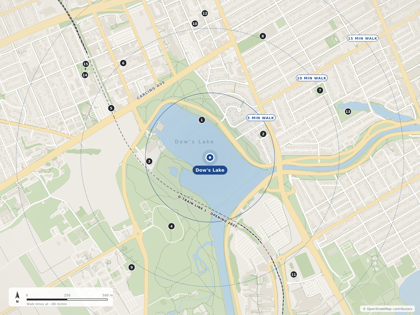
- 1Commissioners Park240 m
- 2Senator Eugene Forsey Park360 m
- 3Royal Canadian Navy Curling Club380 m
- 4Dominion Arboretum490 m
- 5Dow's Lake / Lac Dow680 m
- 6McCann Park800 m
- 7Capital Park800 m
- 8Glebe Collegiate Institute820 m
- 9Ornamental Gardens840 m
- 10Dalhousie South Park840 m
- 11Tennis Centre890 m
- 12Holistic Roots Massage Therapy & Wellness900 m
- 13Brown's Inlet Park900 m
- 14Wading Pool - Ev Tremblay930 m
- 15Ev Tremblay Park950 m
Schools
10 nearbyGlebe Collegiate Institute
OCDSB212 Glebe Avenueopenstreetmap.org glebe.ocdsb.ca ocdsb.ca
820 m10 min walkWestboro Academy
200 Brewer Wayopenstreetmap.org
1.1 km14 min walkMutchmor Public School
OCDSB185 Fifth Avenueopenstreetmap.org mutchmorps.ocdsb.ca ocdsb.ca
1.1 km14 min walkCorpus Christi School
OCSB798 Lyon Street Southopenstreetmap.org cch.ocsb.ca
1.1 km14 min walkÉcole élémentaire publique Louise Arbour
CEPEO175 Beech Streetopenstreetmap.org louise-arbour.cepeo.on.ca cepeo.on.ca
1.2 km15 min walkGlebe Montessori School
650 Lyon Street Southopenstreetmap.org glebemontessori.com
1.2 km15 min walkHeritage Academy
207 Bayswater Avenueopenstreetmap.org heritage-academy.com
1.3 km16 min walkAdult High School
OCDSB300 Rochester Streetopenstreetmap.org ocdsb.ca
1.3 km16 min walkFamily Reception Centre
OCDSB300 Rochester Streetopenstreetmap.org ocdsb.ca
1.3 km16 min walkBlyth Academy The Glebe
983 Bank Streetopenstreetmap.org
1.3 km17 min walk
Straight-line distances from the Dow's Lake centre. Living near a school does not guarantee a place: confirm the designated school for an address with each board. All schools and board locators.
Parks & places
10 nearbyCommissioners Park
240 m3 min walkSenator Eugene Forsey Park
964 Bronson Avenueopenstreetmap.org
360 m5 min walkRoyal Canadian Navy Curling Club
Ice rink
41 Navy Privateopenstreetmap.org
380 m5 min walkDominion Arboretum
490 m6 min walkMcCann Park
80 Norman Streetopenstreetmap.org
800 m10 min walkCapital Park
10 Ella Streetopenstreetmap.org
800 m10 min walkOrnamental Gardens
840 m10 min walkDalhousie South Park
343 Bell Street Southopenstreetmap.org
840 m10 min walkTennis Centre
Community or recreation centre
1125 Colonel By Driveopenstreetmap.org
890 m11 min walkBrown's Inlet Park
65 Craig Streetopenstreetmap.org
900 m11 min walk
Shops & dining
10 nearbyHolistic Roots Massage Therapy & Wellness
475 Cambridge Street Southopenstreetmap.org
900 m11 min walkLa Brioche Pastry & Bakery
866 Bank Streetopenstreetmap.org
1.3 km16 min walkGlebe Meat Market
869 Bank Streetopenstreetmap.org
1.3 km17 min walkWhole Foods Market
951 Bank Streetopenstreetmap.org
1.4 km17 min walkIchiban Bakery
825 Bank Streetopenstreetmap.org
1.4 km17 min walkIl Negozio Nicastro
792 Bank Streetopenstreetmap.org
1.4 km17 min walkWild Oat Bakery
817 Bank Streetopenstreetmap.org
1.4 km17 min walkSecond Avenue Sweets
151 B Second Avenueopenstreetmap.org
1.4 km17 min walkMetro
754 Bank Streetopenstreetmap.org
1.4 km17 min walkPreston Hardware
248 Preston Streetopenstreetmap.org
1.4 km18 min walk
Getting around
TransitDow's Lake / Lac Dow
O-Train
680 m9 min walkCarleton
O-Train
1.1 km14 min walkCorso Italia
O-Train
1.4 km18 min walkDowntown
Parliament Hill is 3.2 km away in a straight line. By road it is 4.0 km, about 8 minutes (free-flow, no traffic). Straight-line distance is from the area centre; driving distance and time are from the OSRM demo router on OpenStreetMap roads, as of 2026-10-30.
O-Train Line 2
Dow's Lake / Lac Dow station is open. Wikipedia says Carling Station was renamed Dows Lake Station when Line 2 reopened in January 2025, although the lake is about 300 metres away, and that trains run every 12 minutes. Confirm current service with OC Transpo.
Other nearby O-Train stations
Carleton, Corso Italia and Bayview stations, all shown as open in OpenStreetMap. We have not measured distances to them.
Commute habits (ONS 'Glebe - Dows Lake' area)
In the 2021 census, 55.4% of workers commuted by car, truck or van, 8.8% by public transit and 55.1% worked at home. These are separate census shares, not parts of one total.
For sale in Dow's Lake
No Dow's Lake homes on dowslake.homes right now
Selling here? Get a website for your home, or browse every home for sale in the area.
Neighbouring areas
Quick answers
Short answers first; each links to the full answer and its sources.
Is Dow's Lake a good place to live?
Dow's Lake sits beside the Rideau Canal in central Ottawa, about 4 km by road from Parliament Hill, and its O-Train station is open. The Ottawa Neighbourhood Study's 'Glebe - Dows Lake' area had 13,565 residents in the 2021 census, and 51.3% of households rented. Whether it suits you depends on what you need, so here are the facts.
As of 2026-10 · ons-sqo.ca router.project-osrm.org
What schools serve Dow's Lake?
No school sits on the lake itself. The nearest board-run schools listed on OpenStreetMap are Glebe Collegiate Institute (secondary, 212 Glebe Avenue) and Mutchmor Public School (elementary, 185 Fifth Avenue), both Ottawa-Carleton District School Board. Corpus Christi School (798 Lyon Street South) is Ottawa Catholic School Board, and École élémentaire publique Louise Arbour (175 Beech Street) is French-language, Conseil des écoles publiques de l'Est de l'Ontario.
As of 2026-10 · glebe.ocdsb.ca mutchmorps.ocdsb.ca
How far is Dow's Lake from downtown Ottawa?
Parliament Hill is about 3.2 km in a straight line from the Dow's Lake area centre. By road it is about 4.0 km, roughly 8 minutes in free-flowing traffic.
As of 2026-10 · router.project-osrm.org openstreetmap.org
What are homes like in Dow's Lake?
In the 2021 census, the ONS 'Glebe - Dows Lake' area had 6,885 private dwellings. About 27.6% were single-detached houses, 29.4% were apartments in buildings under five storeys and 22.7% were apartments in buildings of five or more storeys.
As of 2021 · ons-sqo.ca ons-sqo.ca
What is the nearest O-Train station to Dow's Lake?
Dow's Lake station (listed on OpenStreetMap as Dow's Lake / Lac Dow) is the nearest O-Train station. It is open and sits about 0.7 km north-west of the area centre in a straight line.
As of 2026-10 · openstreetmap.org openstreetmap.org
Where do people in Dow's Lake buy groceries?
The nearest grocery stores mapped on OpenStreetMap are on Bank Street in the Glebe: Metro (754 Bank Street), Il Negozio Nicastro (792 Bank Street) and Whole Foods Market (951 Bank Street). Each is roughly 1.4 km in a straight line from the Dow's Lake area centre.
As of 2026-10 · openstreetmap.org openstreetmap.org